The first part of the hike was in Naugatuck State Forest, Sanford Block, and included the highest point along the Quinnipiac Trail: Mt. Sanford at elevation 890 ft. First there was a false summit, which had the only really good vista for the day. A wooden box nailed to a nearby tree held a couple of notebooks for people to jot down their thoughts, and judging by the volume of comments a lot of people must walk up there.
 Near the true summit I found one large pile of rocks and many smaller piles of rocks at intervals that made me suspect this might be a Native American ceremonial site. No view there, but when the trees were cut you would have been able to see for miles to the east and west.
Turning over a rock I found an ENORMOUS grub - a couple inches long! It's the larvae of the Giant Stag Beetle, a beetle that I believe could kill and eat a small dog.

There was lots of Witch Hazel in bloom along the hike. Witch Hazel is used as a medical astringent to reduce inflammation of sensitive tissues (hospitals give it out post-child birth) and nearly all of it is harvested locally.
 How often I find the remnants of balloons in the middle of the forest! Grrr. Releasing a balloon is littering, people! At least this one didn't fall in the ocean to be ingested or to tangle up wildlife.
 At one point I heard the sound of an amplified Indian Flute drifting through the trees from a ranch down below, very much like my hike in Pomfret while they were having a pow-wow in the park. It seemed to belong here. I sat down and had lunch.
There is 'almost a view' for most of the hike, both to the east and west, sometimes at the same time. It was actually a bit maddening. Nothing a little logging couldn't cure.
 The Quinnipiac joined up with a trail for Roaring Brook Falls, the highest single drop falls in the state, so I descended the side trail to have a look. After a few inches of rain the night before, the falls were really humming. This photo just shows one section.
A much shorter but still beautiful upper falls was up by the Quinnipiac Trail:

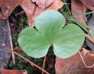
This Hepatica looks like it's getting ready for spring:
 This chipmunk was probably so stuffed from the bumper crop of nuts it couldn't move:
 Parts of the hike were on an almost razor's edge, with the land dropping off quickly to the east and west. Nearly the entire route of the Quinnipiac is along the top of trap rock ridges made of hard basalt that was once molten rock. I just wish there were a few VIEWS.
The trail ends at this survey monument marking the town boundary line for Cheshire and Prospect. Well, technically the trail goes up the road and then ends, but I don't understand that at all. As far as most people are concerned the trail ends where it comes out of the woods and hits the end of Cornwall Avenue in Prospect.


No comments:
Post a Comment