Saturday, May 1, 2010

Housatonic River Cleanup

Perfect weather for the annual Housatonic River Cleanup, a multi-city effort organized by John Valentino and, in Shelton, Leon Sylvester Jr. , and lots of help from area marinas and businesses. We showed up around 10:00 am at Sunnyside Boat launch and found the event tent next door at Ayers Landing Marina. The event started at 8:00 am and the free T-shirts had been picked over, so I got a leftover from 2009.

Boats were taking people out to the islands and distant shorelines, and bring back the collected garbage. Our timing was bad and we had to wait about 20 minutes for the oyster boat that would take us to our destination. It was nice boat ride and we passed some rowing crews in their sleek red racers.

We passed lots of people who had been picking up litter for a couple hours already.

We were dropped off at Two Island Island, which is actually a peninsula that has been used as a gravel quarry for quite some time. Our shore was jagged boulders with rebar jutting out randomly - a treacherous shoreline. But we set to work.

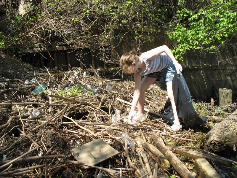
The boulders, the huge poison ivy vine my daughter mistook for a tree, pricker bushes, and incoming tide made for very slow cleaning. There were three of us and it took a good hour to collect just three bags of litter.

How much easier it would be for people to pick up this litter when it is still on the streets! Because that's where it all comes from: Street litter is washed into storm drains during heavy rains, and from there it flows straight into our streams, eventually making its way to Long Island Sound. I'm always surprised at how many people think stormwater goes to a treatment plant.

On a random note: See all that "bamboo" debris in the photo above? It's Japanese Knotweed stalks, an invasive species.

Around lunch time the oyster boat came back to pick us and our garbage up (it was a challenge getting back in the boat!). Almost all the non-crew volunteers were from Shelton High School.

After dropping off passengers at the dock, the oyster boat went to the boat launch to drop off the garbage. Six-Foot subs were on the way, but we had things to do and took off.

This is how much had already been collected by lunchtime, with another four hours of clean-up to go.

Saturday, April 24, 2010

Spring Arrives at Sleeping Giant

It was five months ago that I journey down the west slope of Sleeping Giant at dusk, having lingered too long at the top looking for treasure. My intentions were to return soon, as I had unfinished business there, but Mother Nature intervened and coated with the slopes with ice and snow for the season. Yesterday I finally returned to the Tuttle Ave parking area for the Red Trail and was greeted by a host of spring wild flowers. That's Red Trillium above.

The tiny Fringed Polygala was quite dramatic along the lower trail. I wondered if I had found something rare (this is possible at the Giant), but there was a handwritten note in my copy of Newcomb's Wildflower Guide that I had seen this same species in 1992 -- at Sleeping Giant.

The red circle trail follows a stream to the top of the ridge, at one point taking you high above Gorges Cascades, a mini-canyon of sorts. A bit higher was a classy waterfall that this picture does not do justice to, alongside a small cave. The cave rock was conglomerate (sedimentary rock) and the falls flowed over "trap rock" or basalt (previously molten rock), so there's a bit of geology going on there.

An old bird nest was built right into the side of the cave next to the falls. I don't know what kind.


Bloodroot and Dutchman's Breeches were done blooming, but their delicate leaves hadn't yet gone dormant.

Dwarf Ginseng was all over the lower slopes.

The stream goes up and up and eventually leads through a notch in the ridge to this sprawling red maple swamp on the mountain.

Turning onto the blue-blazed Quinnipiac, the terrain became rockier and drier, home to the occasional Columbine.


Last time I was here the trees were bare. What a sight to see!

Letterboxing at the Giant is strenuous. It may seem like there are a lot of boxes in the park, but there are many miles of trails and the boxes are really spread out. I generally find I'm spending at least one hour per find. This time I spent eight hours for five finds (and five not found). Many of the boxes are older and have gone missing, or if you do find them, they may be wet. But there are a lot of real classics and great carvings, and if you go looking for them all I guarantee you will find yourself exploring all sorts of nooks and crannies you never knew existed at the Giant.

After descending the west slope, I couldn't help but drive around to the main parking area to look for a few more, returning to the Mill River...

...and the quarry (see the grayish spot on the cliff to the right? That's where a chunk of the mountain collapsed a couple years ago)...


...and the ruins of the quarry infrastructure.

And that's all for now: I've looked for every box that I know of at the Giant. On to some other park.

Wednesday, April 14, 2010

Fort Hale, New Haven

What a nice little spring diversion with the kids during Spring Break. Fort Hale sits on a low outcrop of traprock that juts out at the entrance of New Haven Harbor, providing the perfect spot for fortifications as far back as the 1600's.

There's a nice reconstruction of the Revolutionary War fortifications, then called Black Rock Fort (the name and size changed with each war), all located right next to a small beach, playground and fishing pier. A huge container ship headed out of the harbor, perhaps headed for China.

The main entrance to the fort was closed, so we parked at the beach and walked over along the shoreline. It wasn't far.

After enjoying Black Rock Fort at the point we explored inland, where the larger Fort Nathan Hale was located (Wars of 1812 and the Civil War).

We found that two small hills were actually man-made fortifications for the soldiers.

And here's something you don't see every day: a reconstructed Civil War drawbridge over a moat.

Fort Hale is one of those overlooked spots in the region. I suspect the beach area is pretty busy in the summer, spilling over to the Fort, but it was just perfect for a warm spell in April.

Sunday, April 11, 2010

Wildflowers Vs Invasives at Birchbank

Birchbank has more early spring wildflowers than anywhere else I know of in Shelton. But it also has some serious issues with invasive species. Garlic Mustard, Japanese Knotweed, and Japanese Barberry are the worst problems. In the photo above you can see a native Trout Lily (left) and Red Trillium (right) being overrun by invasive Japanese Barberry.

Japanese Knotweed, a tall plant some people call Cane, is notoriously difficult to kill, and can survive repeated applications of Round-Up. Near the parking area, the knotweed is spreading into areas that were once solid mats of Dutchman's Breeches and Red Trillium. In the photo above you can see flowering Breeches along with old stalks from the Knotweed and fresh Knotweed sprouts.
The surviving Dutchman's Breeches also have to contend with illegal ATVs trampling the area.

The sprouts of Japanese Knotweed are edible, and though they look like asparagus they taste more like tart rhubarb. There are lots of recipes online. Garlic Mustard is also edible and in fact was brought to this country for cooking. Garlic Mustard pesto is very good.

Here's a Red Trillium competing with the Japanese Knotweed. At least it gets out early each spring before the Japanese Knotweed can overtake it. Here's a video about Japanese Knotweed.

Saturday, April 10, 2010

Birchbank Wildflowers


If you appreciate early spring wildflowers, now is the perfect time to visit Birchbank Mountain Open Space. If you park on Birchbank Road at the RR crossing (the parking spot is currently in sad shape) after only a few hundred yards you will be surrounded by a blanket of Dutchman's Breeches.
Walk along the flat old road (it gets muddy from the illegal ATVs), skipping the left turn up the hill marked by white blazes, until you get to Upper White Hills Brook, which is split in two. Not far up the bank is the cascades (above). This spot is amazing for spring wildflowers -- All the flower pictures below were found along the stream and trail in that one spot.

Red Trillium - a favorite.


Blue Cohosh, almost in bloom. The big blue berries persist into the winter and are striking.

False Hellebore. Not in bloom, but an attractive alternative to skunk cabbage. There's lots of it there.

Trout Lilies are traditionally in bloom on April 15 - opening fishing day.

Unidentified species of violet. The yellow ones are not as common.

Cut-Leaved Toothwart.

Dwarf Ginseng.


Be prepared for some mud and water crossings. The ATVs have just made a mess of this otherwise beautiful old colonial road.


A neat pair of tracks: a raccoon hand next to a pair of tiny mouse or chipmunk tracks.

Friday, April 9, 2010

Tame Toads

Here's a pair of lovebirds in my gold fish pond a couple days ago. They were like that all day. Daddy (the little one), never released his hold. Mommy would dive down from time to time, and he just hung on. But mostly they just sat in the sun while we worked in the yard.

Toads are amazingly tame and make wonderful pets. Taking the picture above, I was actually able to pick off some vegetation from Mommy's head without her moving. As a teenager I trained my pet toads to eat hamburger out of my hands (you start by putting raw hamburger or bologna on the end of a broom straw and twitch it, gradually shortening the straw).

When my son was about six, he brought a huge toad home from Vermont. I thought the poor thing might be traumatized by the long ride and fidgety boy. But the toad immediately began catching flies out of the air while my son was carrying him around.

The toads have been trilling from random ponds the past week or so. They live on land (and LOVE to eat ants), but lay eggs in the water in long strings that they wrap around vegetation. The tadpoles are jet black. Here's a short video of another toad trilling in my pond.

Some ponds get invaded by toads, like this one at Jones Family Farm in Shelton.


Sunday, March 14, 2010

Gristmill Trail Flood

And that's why they call it a flood plain! This flood plain is located along Gristmill Trail and the Far Mill River in Shelton. Every year there is a flood or two, but not always this big. See the blaze on the tree above marking the trail location?

There was quite a current in the river today. The Far Mill River drops in elevation pretty rapidly, which is why so many mills were located alongside the river. That gives it a strong current. Kayakers also enjoy the current, and are seen putting in at this spot during floods.

This river is only for very experienced kayakers, however. In addition to some falls, there are large standing waves like the one above, caused by rocks below the surface.

Sunday, March 7, 2010

Diurnal Fireflies

While painting blazes this past weekend, I kept running into these beetles and sometimes even had to flick them away. They're very common on tree trunks this time of year. I'm sure you've seen them at some point. Today I grew curious about the beetles and looked them up.

They happen to belong to a genus of fireflies that don't light, also called "diurnal fireflies" because they are active during the day. They breed on the tree trunks in March, which is why certain tree trunks have a lot of them.

Here's the underside of the firefly. The abdomen is all black, unlike most fireflies, which have a light-colored lower abdomen where they light up.

If this sort of thing interests you, here is a really nice description of these fireflies and how they live.

Sunday, February 28, 2010

Indian Hole Bridge, WPA Project

This is Birchbank Road in Indian Well State Park in Shelton. Many people drive over the bridge and barely notice it. It's located just after the parking area designated for the Paugussett Trail and for the waterfalls that give the park its name. The photo above was taken from the very beginning of the Paugussett Trail, where I was trying to match up blue paint for some reblazing at Shelton Lakes this spring.

I meant to walk up to the falls, but found the bridge more interesting. This bridge, as well as other stone work at the park, was a WPA project, the 1930's version of "stimulus spending." The Paugussett Trail was also created during the Great Depression by using CCC workers.


Indian Hole Brook is shallow, even today after all the rain we had a few days ago, so it's possible to walk underneath and admire the effort it must have taken to build this bridge by hand.


Over the past 75 years or so, stalactites have formed. Some are six inches long. Bridge stalactite are made of gypsum, and form much more rapidly than cave stalactites, which are made of limestone.