Wednesday, September 29, 2010

My Carrots and Their Ancestors

Growing in amongst our carrots this year was lots of Queen Anne's Lace. The leaves are very similar, so we left them, never quite sure which was which. When it was time to dig up the carrots, here's what we got. The ones on the left are the weed, which coincidentally happens to be the ancestor of the cultivated carrot (Queen's Anne's Lace is also called "Wild Carrot"). No wonder they look so similar!

Breaking open a root, the Queen Anne's Lace looked quite different from a normal carrot. It's not considered to be edible. The modern carrot is said to have a mutation whereby some really tough, woody tissue in the root (xylem) is missing, making them edible. I'll take their word for it.

When I picture Queen Anne's Lace, I picture flowers, not roots. The photo above is Queen Anne's Lace near Short Beach in Stratford. This flower grows up and down our highways. And when I picture carrots, flowers don't come to mind. I've never seen a carrot flower. Have you? So here's a link to an agricultural field of carrots in bloom. Look anything like the above photo?

Thursday, September 23, 2010

Japanese Knotweed - Death by Lethal Injection

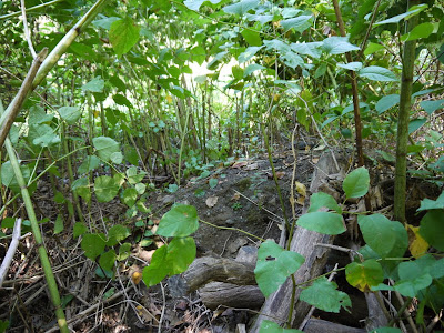
Japanese Knotweed is infamous for invading, conquering, and taking over large swaths of ground, replacing the native vegetation with impenetrable stalks of "cane" that can easily grow twelve feet tall. Here's a patch measuring about 50 ft x 50 ft (and spreading), located near the trailhead for Nells Rock Trail, off Nells Rock Road in Shelton. According to Wikipedia, its roots can spread out up to 23 feet and go down up to 10 feet.

Once established, it is nearly impossible to eradicate. People have tried herbicide spray, digging it up, and covering it with sheets of plastic, with poor results. Instead, it is necessary to inject concentrated herbicide into the hollow stems, and they've even invented a tool for this: the JK Injection Tool, said to be 98% effective. This is the best time of year for that (the poison is drawn down into the roots), and so I spent a couple hours one morning attacking the patch at Nells Rock. I used a Sharpie to mark which canes had been injected. Only the canes that are injected will die. So each stem must be injected.

The Knotweed towered a good six feet over my head.

Here's a clue as to where the Knotweed came from. The plant was growing out of piles of gravel yard scrapings that had been dumped here long ago. The Knotweed had come along for the ride.

It's most efficient to attack small clumps before they become established, so I targeted this new patch along Hope Lake and the Rec Path. There were a total of only eight stems to inject. Hopefully those Knotweed plants are gone for good. We'll find out next year.

Here's another small patch growing along Hope Lake and Nells Rock Road. This patch is more of a problem since there are lots of small stems. The injector tool doesn't work on small stems -- it just splits them open. So I'll need another plan of attack for this clump.


Future projects: The Bluff Walk at Riverview Park is currently routed onto pavement at the basketball courts because there is a huge stand of Knotweed in the way (above). If I can kill off that Knotweed, we can get the trail off of the pavement. That's a big project, however, possibly for 2011. There is also Knotweed overrunning native wildflower areas at Birchbank Mountain, and some relatively new patches along the Blue Trail near Constitution Blvd North.

Tuesday, September 21, 2010

Ansonia River Walk

Here's the location of the future Ansonia River Walk, which will continue north from where the popular Derby Greenway ends at BJs on Division Street. This photo was taken north of Division Street and south of Target. There was a ceremonial groundbreaking held recently.

Massive flood walls and berms were constructed along the Naugy after the catastrophic flood of 1955, and these walls have cut residents off from seeing their river for the past 50 years or so. Here's a video of the 1955 floodwater going down Main Street in Ansonia. All that rip-rap is not the most attractive river shore, but it does help keep the river in its banks, and the water is still nice to look at from up above. May as well make the best of it, which is what they're doing with the River Walk.

After a summer of drought, the river is practically dry, revealing some great clean-up opportunities for civic-minded groups. The Naugatuck River has come a long, long way since the days when it was nothing more than an industrial sewer that ran a different color each day. The water quality is far better than it used to be, but there's still some unsightly junk here and there.

There's lots of Dogbane growing along the berm. Note the long, stringy seed pods. Native American's used Dogbane fibers to make hemp cordage -- here's a demonstration video, proof that you can find absolutely anything on the Internet. If you want to harvest Dogbane to give that a try, please make sure you're not taking the plant from conservation lands, where the plant is intended to remain as part of the food chain. You might find it in a vacant field or along a highway.

Sunday, September 12, 2010

The "Tick" in "Tick Trefoil"

How did it come to this??? She just had a bath and brush the night before!


That's the culprit right there, earlier in the year. Showy Tick Trefoil. That picture was taken in Easton, but I also saw it growing in Shelton along the powerline section of Turkey Trot Trail. The burrs in the picture above were in Naugatuck. So it's basically everywhere and that seed dispersal strategy must be working pretty well. The plant is called "Trefoil" because it has three leaves, and "tick" because the seed pods stick to everything and go for a ride like little ticks. The "Showy" part in the name is due to the fact that most trefoil species are much smaller and have tiny flowers. I had to throw out my socks this day, as they were so covered with the burrs!

Naugatuck State Forest: The Quiet Side

We went in search of a DEP official letterbox at Naugatuck State Forest. This is the section west of Route 8 where there are no marked hiking trails. Last fall I abandoned my search for the box when I found myself surrounded by gun fire coming from all directions as well as a couple of game wardens as dusk approached. It's apparently an insanely popular place to hunt. So if it's hunting season, go on Sunday. Seriously.

I like state forests. They're managed and therefore healthier for wildlife than most state parks, land trust properties, and even some exclusive "Wildlife Habitats" maintained by groups like Audubon (the ones where I can't go with my dog). A hands-off approach in a suburban forest, which some well-meaning people equate with being natural and therefore better, typically leads to low biodiversity and all sorts of problems for our plants and wildlife. I wish people would get that.

There is, of course, deer hunting, and while I don't much care for hiking while armed men are hiding in the trees, I do like seeing the results: food and shelter for wildlife. State forests are also logged, which creates these open brushy areas (above) filled with lots and lots food and shelter.

These numbered trees for a forest study are another sign of a managed forest. Lots of saplings were shading out the forest floor, but Sarsaparilla thrived.

Bristly Aster was growing along the gravel road. I associate this plant with the ridges of Sleeping Giant State Park, where it grows rather magically in bare rock.


Here's some Indian Cucumber Root, wilted from the drought, and changing color already.

After finding the letterbox, we walked further down the gravel road and came upon a pond held back by this berm covered in goldenrod.

The pond was mostly lily pads. Didn't see any sign of fish, but there were lots and lots of frogs.

The Goldenrod was spectacular. I don't often say that.


This Yellow Bear caterpillar was eating Milkweed.

The Many-flowered Asters were just opening up. These are pretty common. They're also called Heath Asters because their leaves look like needles, as do many heath plants. But there is another aster also called Heath Aster, so that can be confusing. Note how each little stem coming off of the main stem is just covered in a line of flower buds. That's very distinctive for the asters.

Joe-Pye Weed and Boneset added their color to the Asters and Goldenrods on the berm.

This tree growing right in the water is a Black Gum or Tupelo tree. I prefer to call it a Tupelo, and that dredges up a Van Morrison song in my mind every time I see it (the older folks will know what I'm talking about). It doesn't look terribly healthy with its leaves already turning red.

We enjoyed our quiet little walk. No other hikers or bikers, although we did note some ATV tracks (not legal). There aren't any trail maps that I know of.

Friday, September 10, 2010

Arcadia Forest, Rhode Island

There are miles and miles of old roads and trails running through the massive 14,000 acres of Arcadia Wildlife Management Area in Exeter, Rhode Island. That's a BIG park: about ten times bigger than Sleeping Giant State Park, and about ninety times larger than Indian Well State Park here in Shelton.


The relatively flat sandy areas are covered with pines, scrubby oaks, and blueberries, reminding me of the sandy forests of northern Wisconsin (above). The glacial outwash sands in both Rhode Island and Wisconsin are responsible for the similar appearance and vegetation.

The sand dries up quickly, so plants must be adapted to drought, especially up on Bald Hill (Really? That was a hill?). Not many species can tolerate the dry conditions, so there is not much diversity, and most of the woods are rather open, often covered with a low layer of heaths such as Huckleberry, or pine seedlings.

Arcadia is crossed with miles and miles of sandy roads and unmarked trails, along with a few trails that are actually blazed for hiking. Arcadia Trail (above) is one of the few that has been blazed. The trail maps at the park are nearly useless, since there is a labyrinth of unmarked trails and it can be difficult to know where you are on the map. This is one place a gps receiver comes in really handy. So I naturally lost mine towards the beginning. It's still out there somewhere. The best map I've found online is here. You need to download it and crop to the area you want to explore.

The park was not at all crowded. Over the coarse of seven hours of hiking on a Friday, I passed one hiker walking her dogs, one mountain biker, and two groups on horseback. That's it. The forest is a management area, so there is hunting and possibly logging, and dogs need to be leashed during bird nesting season. I'm sure the healthy forest is due in no small part to the fact that the forest is managed. Over the many miles I hiked, I saw only native species. How refreshing! I can't remember the last time that happened.

Browning Mill Pond in the center of the park is an attraction. The ponds again remind me of northern Wisconsin, a pothole region, although these ponds are actually reservoirs.

This Indian Cucumber Root was growing near the pond.

East of Arcadia Road is a handicapped-accessible boardwalk that just goes on and on. The forest changes to a more typical Connecticut-type forest as the subsurface reverts to bedrock instead of sand.

The boardwalk leads to some picnic alcoves along another pond.


Heading off-trail for a bit, I came upon yet another grid-like series of rock piles on a ridge. Some people think these ridge-top piles were placed by Native Americans for spiritual ceremonies. Others think they were put there by farmers, either White or Native. Since I only find the piles on ridge tops where I would not expect the best farmland to be, I tend towards the first explanation.

Friday, September 3, 2010

Community Garden Scenes


No rain from Hurricane Earl, so I grab some shots before picking my tomatoes and squash. Update: Preregistration forms are available here (or pick one up at City Hall).